 آکادمی رابعی اخبار ، مقالات ،آثار و برنامه های مهندس حمید رابعی
نوشته های مشابه
Hamid Rabiee, Master of Urban Engineering, emphasized on climate change in the Central Plateau of Iran . He referred to the plan to transfer water from the Persian Gulf to the Central Plateau of Iran, which is the result of years of research and study of Iran’s climate, ways of climate change and similar examples in other countries by a large number of engineers and scientists, including Hooman Farzad and Engineer Shahbodaghi states that he has called for the planning of state and military officials in order to approve and implement this plan.
Hamid Rabiee, referring to the existence of two large deserts, Dasht-e Kavir and Lut Desert, as well as Hamoon Jazmourian and proximity to international open waters in the south, the most important and effective way to change water transfer through various channels such as digging canals or tunnels. He described the climate as highly sustainable in the country and added that many countries in the world have taken great steps in the past years to benefit the sustainable change of their country’s climate for the benefit of nations and the environment.
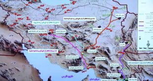
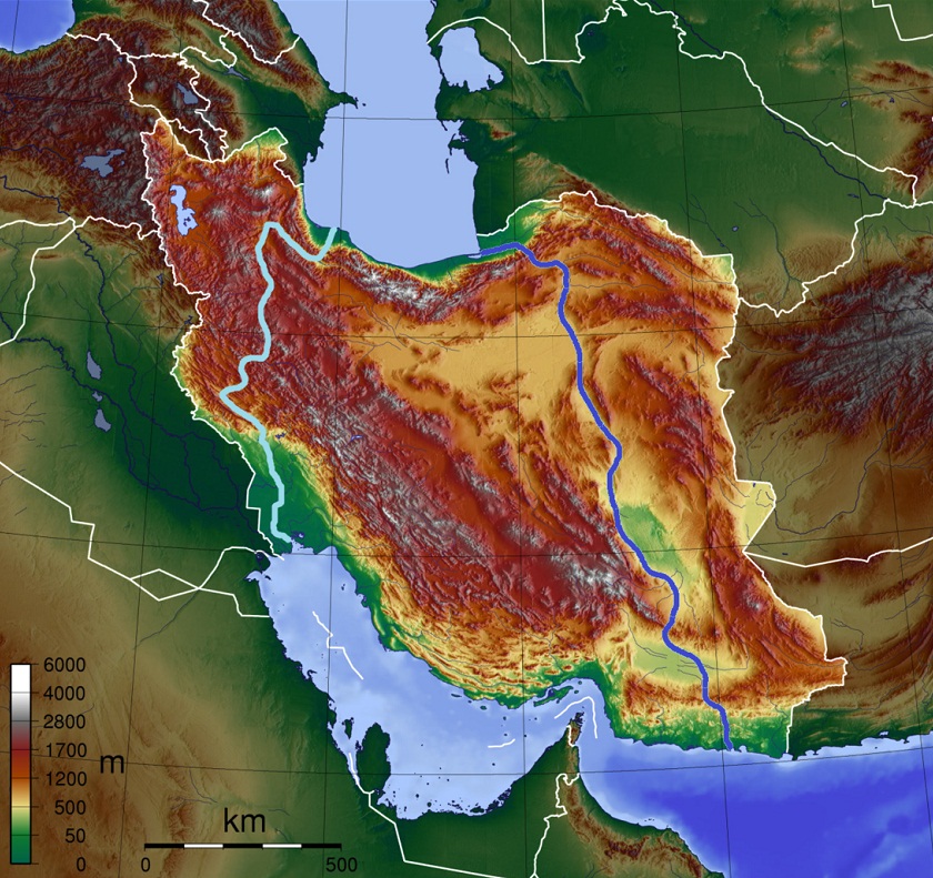
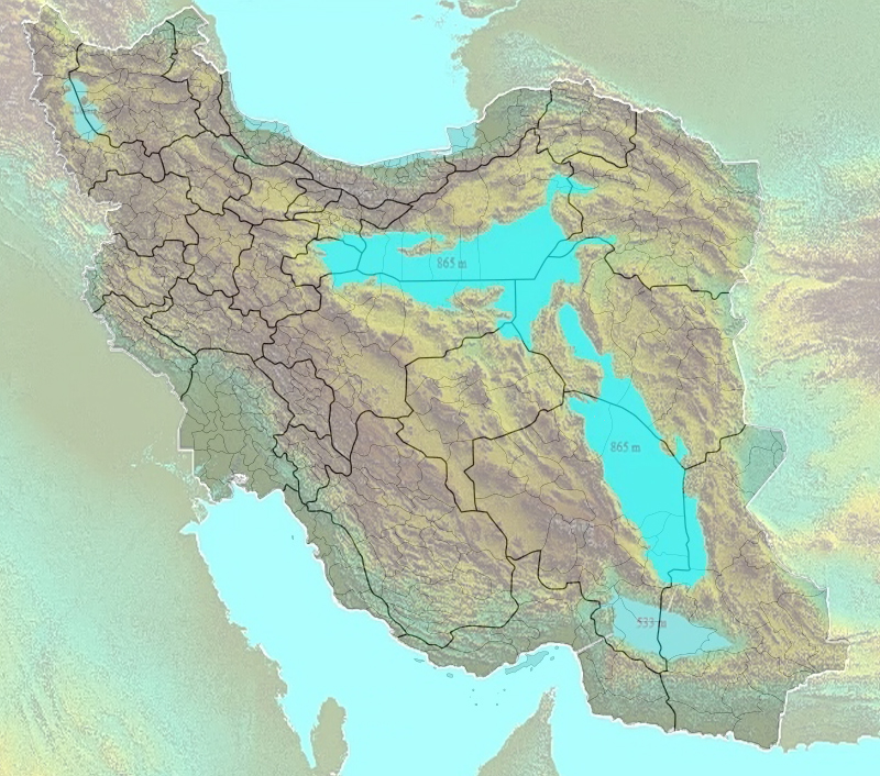
Water transfer route from the Persian Gulf to Jazmourian Lake with an area of about 20,000 square kilometers and from there to Lut Lake with an area of about 76,000 square kilometers by digging 125 km of underground tunnels and two wells 500 meters and from Lut Lake to Salt Lake with an area of about 86,000 Square kilometers by digging a 21-kilometer canal
Hamid Rabiee further added that the existence of three large lakes, Lut and Jazmourian and the central plain, which are connected to each other by a main canal to open waters and 5 sub-canals, will definitely affect the climate of large areas of neighboring provinces and consequently the whole country. Creating susceptible areas and sustainable habitats will transform humans, animals and plants
Referring to projects such as Iranrood that aspire to connect the Caspian Sea and the Persian Gulf, Rabiee added that due to the difference between the Caspian Sea and open waters, this idea will be doomed to failure from the beginning, while the need to connect the Caspian Sea to open waters. It does not exist because its only advantage is the creation of a waterway for the transit of goods, which can be covered by investment in railways and roads.
He described the water problem in the cities around the central regions of Iran as the most important cause of migration and various social harms that will impose great catastrophes on the country, even in the short term, and this plan will certainly prevent such crises.
Referring to the history of such projects by Iranians and other nations of the world, Rabiee pointed to the creation of the Strait of Suez and the Gibraltar Canal in recent centuries, as well as the Panama Canal in Central America, which have led to major economic and climatic changes. These designs are impressive
After years of studying how to supply water to the deserts of the Iranian plateau, Engineer Mahmoud Shahbodaghi has prepared a scientific documentary on the dimensions and method of water supply to the country’s deserts (Dasht-e Kavir; Lut Desert and Jazmourian Wetland, which recently dried up).
This documentary is based on three-dimensional satellite images of the US space agency (NASA) that show the altitude and altitude of the country above sea level. The deserts of the Iranian plateau used to be around the lake and have dried up over the last few thousand years.
Vertical sections that show the height of the four holes of the Central Plateau of Iran (the above three holes and the hole in which the city of Tabas is located) show the extent to which the mountains around these holes can store water. The dimensions of water transfer are astronomical but not impossible. Two or three different phases have been used to transfer water, combining two well-known methods: aqueduct and pump.
To achieve this, an aqueduct with a height lower than the Oman Sea is dug at the mouth of the Persian Gulf to direct water with a slope of about 1 meter to the foothills of Jazmourian Wetland. Then a large water transfer tank is created under the mountain and water is pumped vertically up to a height of 530 meters to fill Jazmourian wetland. Jazmourian will store water for transfer to the Lut desert, which will be re-used in the same way as the aqueduct and pump, and water will be pumped up to a height of 280 meters to fill the Lut desert and then the desert plain. Water transfer time depends on the power and number of pumps. He also has ideas for desalination of seawater that will be made available to the public after the completion of research.
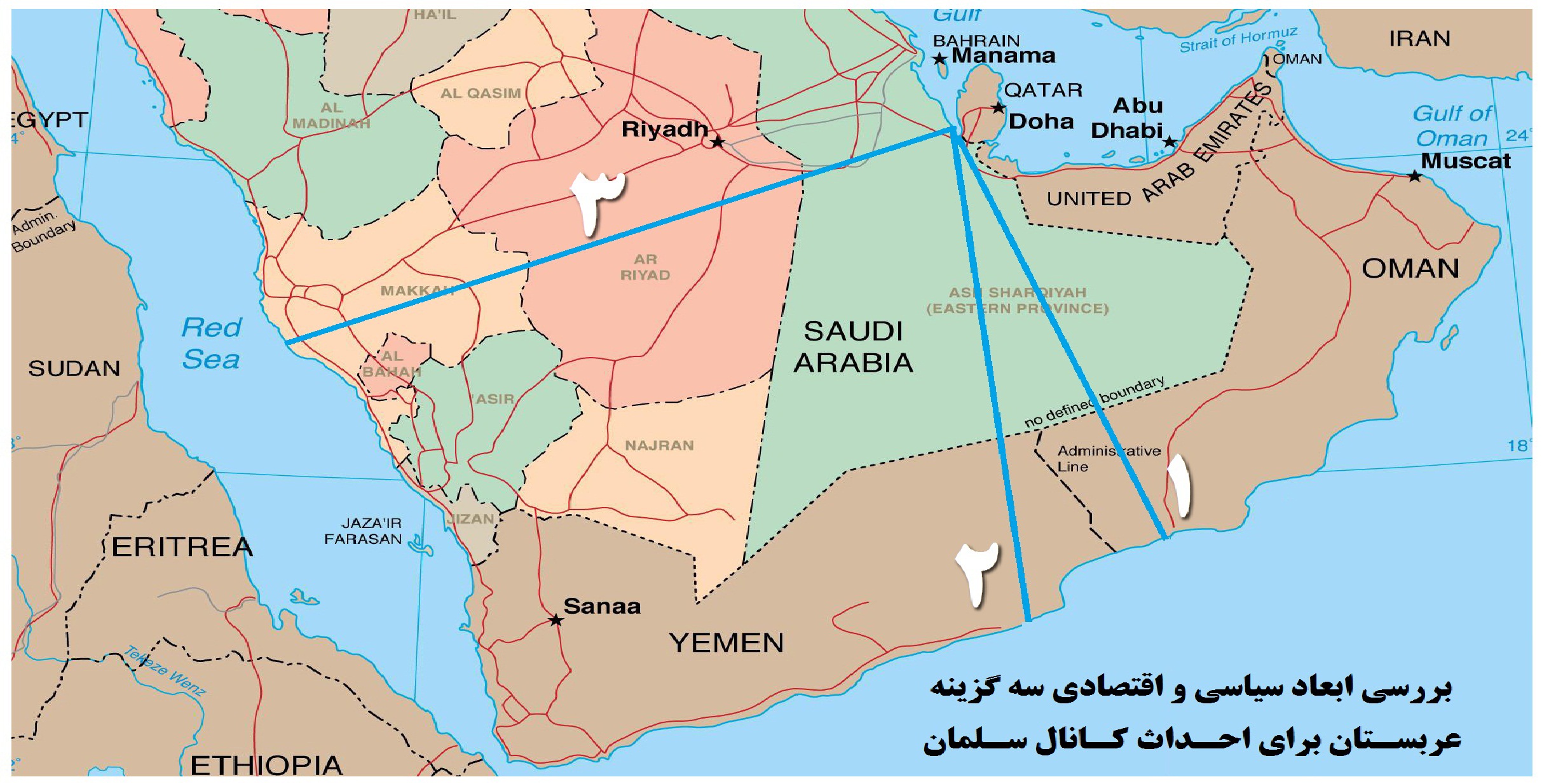
Hamid Rabiee also mentioned the presentation of the plan to create a canal by the Saudi government on the border with Qatar as one of the thought-provoking plans, which in addition to the environmental application of political factors were also involved in its presentation.
Reports about the digging of the canal were first published on the Sabq news site, which is close to the Saudi government. Unknown sources said that the Saudi government intends to build a military base and a nuclear waste dump next to a 60-kilometer canal 200 meters wide and 20 meters deep that would cover the entire Qatari border with Saudi Arabia. The cost of this work is estimated at two billion and eight hundred million Saudi riyals.
In the end, Rabiee pointed out that before this, projects such as connecting the Caspian Sea and the Oman Sea, as well as transferring water through pipes to the eastern provinces of the Oman Sea, had been proposed, which had completely substantial and executive changes with this plan.
Due to the annual increase in global temperature, which will have a direct impact on the melting of polar ice and consequently the rise of international waters, the need to plan and prepare for the threat that the southern coast of the country will be immediately affected. he does
The report of the Office of Infrastructure Studies of the Research Center of the Islamic Consultative Assembly says: The construction of the Persian Gulf-Caspian Sea shipping waterway is technically feasible with conventional methods of crossing the altitude and using engineering knowledge
At present, with the benefit of the experiences of leading countries, it will be possible to conduct the next stages of studies with the focus on Iranian experts.
The report described the plan as “very ambitious at first glance and equally tempting”. Therefore, the question of whether studies in this field will continue or not, certainly has a positive answer.
The Office of Infrastructure Studies of the Parliamentary Research Center acknowledges: This project belongs to future generations of Iran; They are the ones who will benefit the most from the benefits of implementing such a project.
Creating massive employment, generating a steady income, reviving new natural life in about a quarter of the territory of dear Iran, and most importantly, controlling the transfer of significant volumes of oil by Iran will completely change Iran’s economic and political situation.
The importance of the vast economic, political and social dimensions of the great Iran Waterway project is enough that in 1997 the United States included the plan to connect the Caspian Sea to the Persian Gulf in its list of sanctions against Iran. To help Tehran with this project, they were facing financial and economic penalties.
This shows how much the West, led by the United States, fears an increase in Iran’s economic power and a reduction in dependence through the implementation of the Iran Waterway Project.
Overview of the plan to save Iran
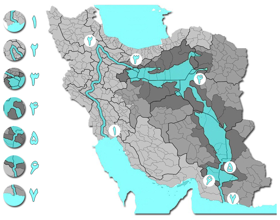
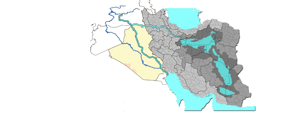
In this huge project, the water of the three lakes of the Central Plateau of Iran, which enter it through the Zagros Canal from the north and the shore of Lake Qom, will return to the Oman Sea from the south, and the water cycle will be performed to prevent possible damage.
۱, entering the Zagros canal and continuing the route to the north with passing 10 lakes along the route to Qom Lake
2, change of direction to Alborz canal and Qom lake
3, enter Qom Lake and cross the last lock
4, crossing the Tabas canal and entering Lut Lake
5, entering Bam canal and Jazmourian lake along 10 lakes along the way
6, exit from Jazmourian Lake and cross 10 lakes along the route of Iranshahr canal
7, entry into international open waters
Some critics have so far prevented officials from focusing on the project, claiming that the creation of lakes and canals would unpredictably change the ecosystem of Iran’s desert areas, although this seems true at first glance. However, it should be noted that the Central Desert region of Iran is considered the poorest region in the world in terms of plants and animals, and it does not seem that the plan to create lakes and canals will further destroy the environment, while the ecosystem of this region has already Iran has been completely different from what we see today, and climate change and ecosystems will bring life back to it.
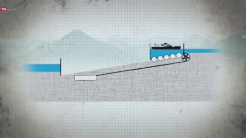
The world’s largest sloping dam was opened in Belgium in 1968, and for about 50 years now it has been transporting ships on a 1,400-meter route about 70 meters in height up or down the canal. The large Iranrood project, previously designed by Hamid A quarter has been proposed that can be constructed in order to connect the Zagros canal to the Alborz canal, using the engineering solution of constructing a sloping dam.


Project background:
The first design was written by Engineer Hooman Farzad in 1345, who presented this design to the Scientific Research Organization of the country. According to this plan, lakes should be created between the Caspian Sea and the Persian Gulf to connect the two seas. In this regard, three low points in Iran, including Jazmourian hole, Lut plain and another desert plain were considered.
The lower level of the open waters of the south compared to the end of the route in the Khuzestan canal is a problem for which there is a practical solution. The solution of this problem is the creation of lakes and reservoirs known as Lock in the connection route of the canal to Qom Lake, by changing the height of its water, the ships of the route can pass through different heights. Such a solution has been tried and implemented successfully in many channels around the world, such as the Panama Canal in the United States and the Caitlin Canal in Europe.
Schematic view of Locke’s working method in Zagros, Alborz and Jazmourian canals
Recently, a similar project was built in China with a length of 1776 km that connects Beijing to Hangzhou. This waterway starts from Beijing and after passing through Tianjin, from Hebei, Shandong, Jiangsu and Zhejiang provinces, to Hangzhou, the oldest history. Parts of this waterway date back to 2500 years ago. This waterway is the oldest and longest man-made waterway in the world, so the long length of the Khuzestan canal should not seem like an unsolvable problem, but the main problem is the length of the project, which must be endured.
Another plan was presented by Mr. Masoud Qomi to Mr. Mousavi, the then Prime Minister. The construction of this canal during the government of Hashemi Rafsanjani and Mohammad Khatami was also examined. The Parliamentary Research Center has also examined the construction of this canal.
Currently, Dr. Badie Badie Al-Zamani in the United States, along with some other Iranian experts, is pursuing this project and has also prepared a project called “Iranrood”.
Drainage of water in the central desert of Iran can be studied as a pilot measure to reduce the level of open waters in the world, and if successful, this measure can be continued in other areas such as sub-Saharan Africa and thus drown countries such as the Maldives. And prevented Pacific islands and cities such as New York and Venice.
Obviously, this action can increase global convergence on an issue that has common interests for all.
The implementation of this plan can serve as a barrier against the smuggling of drugs and goods from the eastern borders to the central parts of the country and abroad. It is possible that various mines can be discovered along the canal drilling route that can be used. It is possible to create marine aquaculture by creating lakes in the desert region of Iran and to create permanent employment and increase food production in the country.
A number of esteemed experts of the “Office of Infrastructure Studies of the Research Center of the Islamic Consultative Assembly” studied the long and extensive five-thousand-page plan of the Ministry of Jihad Sazandegi.
Finally, in November of this year, a report entitled “Study on the feasibility of connecting northern and southern waters” was published by this center.
This report is sometimes referred to as the “South-North Shipping Channel Project Options Review Report”.
Engineer Mahmoud Shahbodaghi, using computer modeling from the latest NASA maps, while proving the confinement of three plains of Jazmourian, Lut and Kavir plain, plans to create three lakes by digging 126 km of tunnels in the north and south of Jazmourian and pumping water in two stages. At a height of 500 meters to the Lut desert and the creation of a 21-kilometer canal to transfer water to the desert plain practically challenged the officials and opponents of this project.
Dr. Peyman Abedi in his book reviewing the effects of Iranrud project on improving Iran’s strategic position, which is the first research work from a strategic perspective to this waterway, has also proposed another project for Iranrud project called Persian Gulf Civilization Waterway.
During the implementation of the Persian Gulf Civilization Waterway project, a river network from the Oman Sea to the Caspian Sea covers almost all important centers and cities of the country’s provinces. In his message regarding his project, he published a book at the beginning of the book to introduce this project. Award: In addition to presenting the new route of Iran River waterway and connecting provincial centers and open waters, it is suggested that while implementing this macro plan in the Islamic Republic of Iran and achieving a special strategic position and position at the international level, this waterway as an indicator Introduce the modern Iranian civilization to the world with the name of the Persian Gulf Civilization Waterway and…
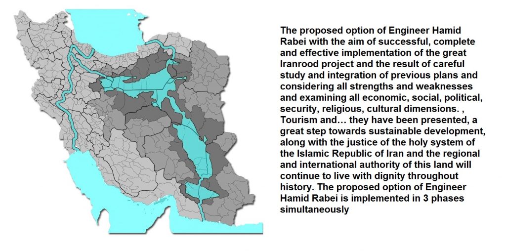
The proposed option of Engineer Hamid Rabiee with the aim of successful, complete and effective implementation of the great Iranrood project and the result of careful study and integration of previous plans and considering all strengths and weaknesses and examining all economic, social, political, security, religious, cultural dimensions. , Tourism and… they are presented, a great step towards sustainable development and development, along with the justice of the holy system of the Islamic Republic of Iran and the regional and international authority of this land will continue in the courtyard with its dignity throughout history. The proposed option of Engineer Hamid Rabiee is implemented in 3 phases simultaneously
He has proposed proposals for the Iran River project under the name of the Persian Gulf Civilization Waterway
During the implementation of the Persian Gulf Civilization Waterway project, a river network from the Oman Sea to the Caspian Sea covers almost all important centers and cities of the country’s provinces. In his message regarding his project, he published a book at the beginning of the book to introduce this project. Award: In addition to presenting the new route of Iran River waterway and connecting provincial centers and open waters, it is suggested that while implementing this macro plan in the Islamic Republic of Iran and achieving a special strategic position and position at the international level, this waterway as an indicator Introduce the modern Iranian civilization to the world with the name of the Persian Gulf Civilization Waterway and…
The proposed option of Engineer Hamid Rabiee with the aim of successful, complete and effective implementation of the great Iranrood project and the result of careful study and integration of previous plans and considering all strengths and weaknesses and examining all economic, social, political, security, religious, cultural dimensions. , Tourism and… they are presented, a great step towards sustainable development and development, along with the justice of the holy system of the Islamic Republic of Iran and the regional and international authority of this land will continue in the courtyard with its dignity throughout history. The proposed option of Engineer Hamid Rabiee is implemented in 3 phases simultaneously

First phase :
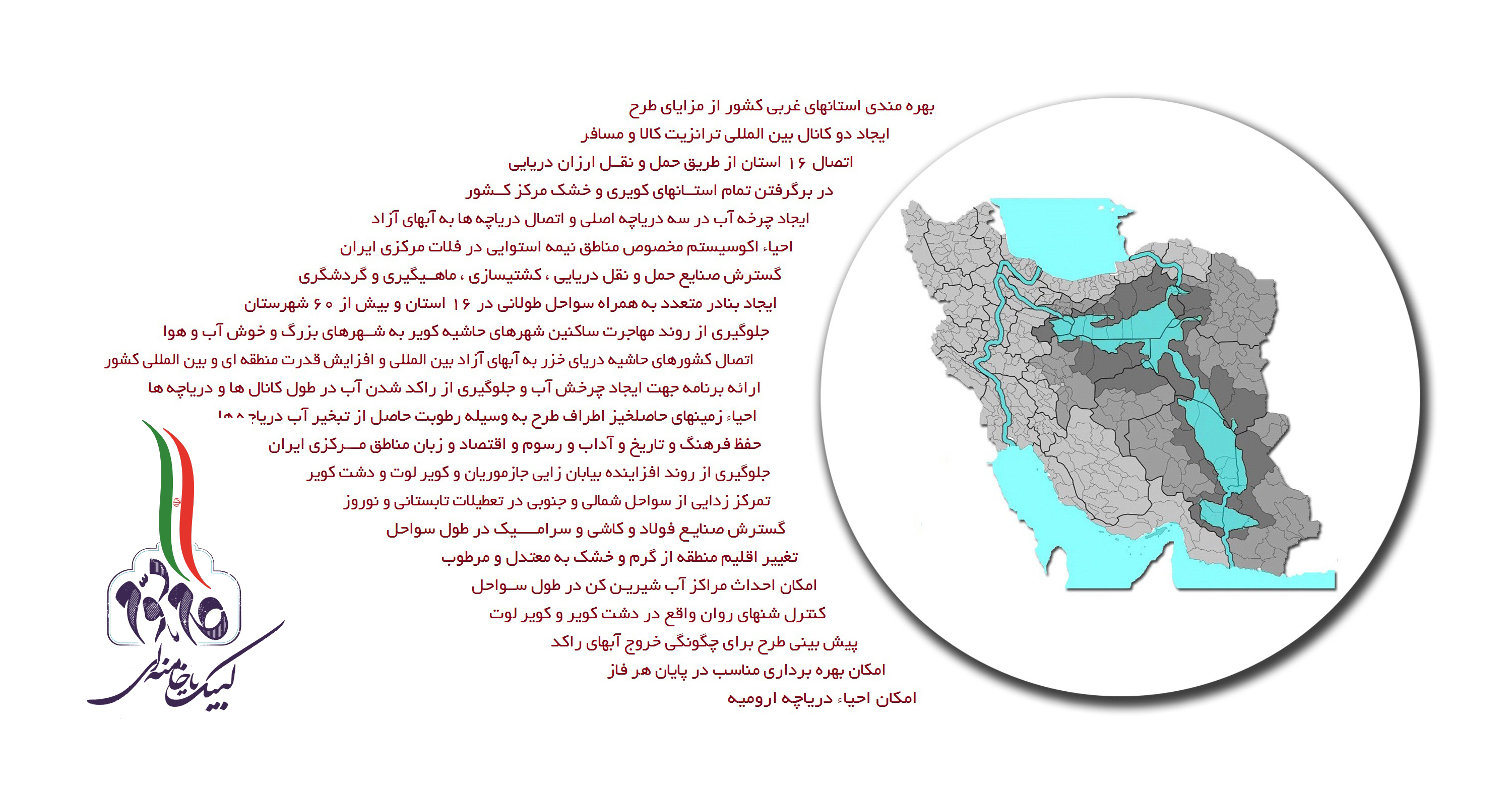
The implementation of the first phase will be aimed at changing the climate of the Central Plateau of Iran and creating sustainable and increasing maritime employment in 9 desert provinces of Iran. This phase will be done in three stages.
In the first phase of this phase, a 91 km long tunnel will be dug from the Strait of Hormuz to Jazmourian Wetland and by digging an aqueduct to a depth of 500 meters and using pumping, water will be transferred to Jazmourian to reach a depth of 533 meters. . During the implementation of this phase, a lake with an area of about 21,000 square kilometers will be created
In the second phase of the first phase, a 35 km long tunnel will be dug from the north of Jazmourian Lake to the Lut desert, and by digging the second aqueduct to a depth of 500 meters and using pumping, water will be transferred to the Lut desert.
At this stage, the depth of Lut Lake will rise to a height of 865 meters and a lake with an area of ۷۶,۰۰۰ square kilometers will be created.
In the third phase of the first phase, a 21-kilometer-long canal will be dug northwest of Lut Lake towards the desert plain to transfer water to a plain with an area of about 85,000 square kilometers and a height of 865 meters in the salt desert.
During the implementation of the first phase, 35 cities in the provinces of Sistan and Baluchestan, Kerman, Yazd, South Khorasan, Khorasan Razavi, Isfahan, Semnan, Qom and Tehran will be added to the coastal areas of Iran, while 182,000 square kilometers of barren sand dunes and dry deserts of Iran Will go to the lake.
The second phase :
The second phase is actually part of the Iran River project in western Iran, which will be designed and implemented with the aim of creating a water cycle in the central plateau of Iran and preventing the accumulation of salt deposits, while at the end of this phase the western provinces of Iran will benefit from the first phase. Will benefit
In the first phase of the second phase, by digging a canal with the capability of ships that after passing through the provinces of Khuzestan, Lorestan and Hamedan will finally change its route from the north of Zanjan province to the desert plain, this time the Persian Gulf water from the northwest The desert plain and the coasts of Qom province will be transferred to the central plateau of Iran.
The second phase is implemented in three stages and 7 main sections
In the second phase and simultaneously with the first phase, a canal will be dug from the south of Lut Lake to Jazmourian Lake and from the south of Jazmourian to Makran coast in the Oman Sea to remove the water that will enter the three lakes in the first phase after feeding them. .
In the third phase of the second phase, the tunnels dug in the first and second phases of the first phase will change their use and the transfer of water through pumping in this area will be stopped.
third phase :
Due to the difference between the surface of the Caspian Sea and open waters and the wide consequences of its connection to open waters and also the very high costs of digging a canal from the heart of the Alborz mountain range, the third phase was designed to connect Caspian littoral countries to open waters in the south. Islamic Iran has been honored and after examining all the economic, political and security aspects of its implementation, in response to the proposal of the plan to the Caspian littoral countries while meeting the demands of neighboring and friendly countries, its implementation with all costs and consequences to them Assign
In this phase, there will definitely be two routes from the east and west of the Caspian Sea, this lake will be connected to phases 1 and 2 and finally open waters to meet the demands of the northern neighbors, the provinces of North Khorasan, Gorgan, Gilan and Zanjan will also benefit from its implementation.
A review of some of the benefits of implementing the proposal of Engineer Hamid Rabei
In the proposal of Engineer Hamid Rabei, there is another alternative option which, if implemented, will be implemented after phase one instead of phases 2 and 3, which were described earlier.
Existence of two permanent rivers Tigris and Euphrates in the west of Iran plateau can provide an extraordinary possibility on the way to Iranrud. Changing the direction of Tigris river in northern Iraq to Azerbaijan in Iran and digging Alborz canal to the entrance of Kavir plain in Qom is one of the ideas That can be examined by experts and officials
Certainly, the participation of Iraq and Iran in this great regional project should be done with the aim of gaining common interests and both countries should benefit from it.
In this project, before the Tigris River flows from the Taurus Mountains to the Iraqi plain, it will enter the Alborz Canal and move east to enter the Central Plateau of Iran in three lakes: Dasht-e Kavir, Kavir Lut and Dasht. It irrigates Jazmourian and finally enters the waters of the Oman Sea from the shores of Makran
Although there are speculations that thousands of years ago, the Tigris River followed the same route to connect to open waters, but for unknown reasons, including frequent earthquakes in the Taurus Mountains, deviated from the first route and took the current route. This natural phenomenon has been one of the many reasons for the drying up of the lakes of the Central Plateau of Iran, including Dasht-e Kavir Lake and Kavir Lut Lake.
There are many opportunities to interact with the Iraqi government in order to make strategic changes in determining new routes for the Tigris and Euphrates rivers so that both countries benefit from it.
The Tigris is a river that originates from the southern slopes of the Taurus Mountains in eastern Turkey. They are flowing. With a length of 1850 km, this river is the 38th river in the world in this respect. According to one historical theory, one of the oldest, or perhaps the oldest, world civilizations emerged between the Tigris and Euphrates rivers.
This river is the historical border of the Iranian plateau, which has always flowed as a natural border between Iran and the lands west of the Iranian plateau. With the invasion of the Arabs and their crossing of this river, Ctesiphon, the capital of the Sassanids, was conquered by the Muslim Arabs along this river.
If a historic and strategic agreement is reached between Iran and Iraq to divert the Tigris River from northern Iraq to Iran, not only will the arid central plains of Iran be revived, but the Iraqi people can also benefit.
Even how to repay the Iraqi government’s multibillion-dollar debt for the eight-year imposed war on Iran can be considered in the same plan.
The eight years of the imposed war in Iran were accompanied by a lot of costs that have not yet been considered by the authorities, and the Iraqi side is making the most of the 30-year passivity of the authorities in Iran, a war that in addition to human costs According to sources collected in the book of Iran’s economy during the imposed war by Farhad Dejpsand, the amount of direct damage to Iran from the destruction of buildings and facilities, machinery and equipment and materials of goods in the total amount It will be 3081 billion tomans at the current rate of 59 to 67. If this figure is converted into rials and dollars based on the official dollar and its change, it can be said that the total amount of war damages imposed on Iran was 440 billion dollars. If it is calculated based on the change of the official exchange rate from 7 Tomans to 2480 Tomans today, it will be included in the daily rate equal to 1.1 trillion Tomans.
These figures show the high depth of war damage imposed on the fledgling Iranian regime. Iran’s total oil revenue from 1980 to 2004, before the golden age of the oil market boom, was $ 432 billion, slightly less than the losses of the imposed war, and taking into account the gold revenues of the last eight years, the total revenue from Iran’s crude oil exports over 32 years The latter amounts to about $ 1,000 billion, which is equivalent to 44% of these revenues’s removed from the country’s economic infrastructure during the war, some of which in some war-torn areas are still the same as they were before the war. Was not rebuilt.
Although Iran was able to end the holy defense with a victory and no part of the country was separated from Iran, but what was lost in this period was the human capital that could be in the early years after the victory of the Islamic Revolution instead of martyrdom And spend money to protect the country’s borders to strive for the prosperity of Iran
Reflection of the plan in foreign media:
In a report titled “Iran Challenges the West”, the Italian newspaper Il Journale addressed the issue of a navigable canal between Iran and Russia connecting the Persian Gulf to the Caspian Sea;
This Italian site considers the construction of a navigable canal that completely passes through Iran not only in Russia’s interest, but also in Kazakhstan, Turkmenistan and Azerbaijan, referring to the 5 km long coastline of the Caspian Sea. Russia writes about this event: Finally, after several centuries, access to the Indian Ocean may be possible for Russia. Because from the last decades of the nineteenth century, Russian engineers sought to create a navigable canal that would allow Russia under Tsarist rule to easily access the Persian Gulf and the Indian Ocean without crossing the Bosphorus.
Russian sites such as Sputnik and Rashatodi have published reports on a plan to connect the Caspian Sea to the Persian Gulf, stressing its strategic importance. The important point of this issue, regardless of the possibility of this project being operational, is the inconvenience and obstruction of the West and Turkey from the construction of this canal;
In a general definition, a lake is a place where water is collected in different ways. During the very long years that have passed since the beginning of life on Earth, lakes have come into various forms. Meteorite impacts, earthquakes, landslides and many other natural causes have caused the formation of lakes. But another type of lakes are artificial lakes, which are mainly formed by humans behind dams. In this article, we want to introduce you to the largest artificial lakes in the world.
Nasser / Nubia
There is an artificial lake on the border between Egypt and Sudan, which the Egyptians call “Nasser” and the Sudanese call “Nubia”. The lake, which covers an area of ۵,۲۴۸ square kilometers, was built between 1958 and 1971.
Caniapiscau
This large artificial lake with an area of ۴۳۱۸ km in the US state of Quebec is the ninth largest artificial lake in the world and also the second largest artificial lake in Canada. This large lake is formed north of the Caniapiscau River and has two dams and 43 earthen canals.
Raul Leoni
This artificial lake in Venezuela, which is built behind the “Guri” dam on the “Caroni” river, with an area of about 4250 square kilometers, is the tenth largest artificial lake in the world. Many consider this dam and the lake behind it to be the main cause of the destruction of parts of the forests in this area.
Lake Kariba (Zambia and Zimbabwe)
Built on the border of the African countries of Zambia and Zimbabwe, this large lake is 97 meters deep in its deepest part and has a catchment area of ۶۶۳,۰۰۰ square kilometers. The dam that created this beautiful lake was opened in 1959 and has an area of about 5580 square kilometers.
Lake Volta (Ghana)
This vast and beautiful lake is the largest water reservoir in the world and is one of the largest in terms of area with 8,502 square kilometers. The lake was built behind the Akosombo Dam in 1915 and has a maximum depth of 73 meters.
Williston Lake (Canada)
This beautiful and spectacular lake was built by the W.A.C and is located next to the Bennett Dam in British Columbia, Canada. The lake, which attracts many tourists every year, is 250 km long and about 1550 km wide, and its water reservoir capacity is about 1700 square kilometers.
Lake Krasnoyarsk (Russia)
Krasnoyarsk is an artificial lake created by a dam on the Yanisey River in 1972. The lake, which is 105 meters high at its highest point, has an area of ۲,۰۰۰ square kilometers and generates about 6,000 megawatts of electricity.
Lake Bratskoye (Russia)
Russia, as the largest country in the world, has a large number of artificial and natural lakes of different sizes. Lake Bratskoye is built in this country along the Angara River and its area is 5470 km. The construction of this lake lasted from 1961 to 1967.
Lake Bukhtarma (Kazakhstan)
This artificial lake with an area of ۵۴۹۰ square kilometers is located behind the dam of the same name and has been operating since 1960.
This dam and its electricity generation complex generate 2 billion and 600 kWh of electricity annually.
Lake Guri (Venezuela)
This artificial lake, also known as Raul Leoni, is built on the Caroni River with an area of about 4250 square kilometers.
The lake is 85 meters deep at its deepest point and the 24 turbines installed on it generate 47,000 gigawatts of electricity annually